
PrecisionFlight for DJI Drones
PrecisionFlight for DJI Drones介绍
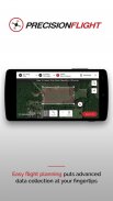
PrecisionHawk’s PrecisionFlight mobile app turns a DJI drone into an advanced remote sensing tool—empowering drone pilots to capture aerial data autonomously. Create flight plans, record video, and capture aerial imagery—all with the push of a button.
Key features include an intuitive and simple flight planning interface; autonomous takeoff, survey mission, and landing; automatic determination of most efficient flight path for data collection including orbit missions around any point of interest; and real-time flight monitoring including altitude, ground speed, mission progress, battery and signal strength, GPS, live video feed, and flight trail.
Additional features:
- Producing flight plans, including grid, orbit, and video capture modes
- Pre-flight checks and emergency safety features like emergency landing and return to home (RTH) technology
- Ability to pause and resume missions
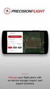
- Storage of flight plans for easy flight plan management
- Online and offline flight planning capabilities with storage of basemaps for non-connected flights
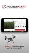
- Customizing camera and sensor settings before your flight
- Optimizing your flight plan using advanced mission controls
- Intuitive and simple one-click video recording
- Real-time tagging of frames as points of interest
- Seamless integration with PrecisionHawk’s PrecisionMapper for processing and analysis
Post-flight, drone operators can upload imagery, tagged video recordings, and other flight data to PrecisionMapper.com, for free. Create and analyze 2D and 3D orthomosaic maps, and gain access to the Algorithm Marketplace for other analytic tools including volume, NDVI, elevation, and much more.
PrecisionFlight is perfect for commercial applications of drone flights across industries like agriculture, energy, mining, insurance, and others. Save and share data safely and securely with your team across personal devices. Upload all gathered drone data and imagery to PrecisionMapper for further analysis.
PrecisionFlight is compatible with DJI’s latest drones: Matrice 200, Matrice 600, Matrice 100, Phantom 4 Pro, Mavic Pro, Inspire 2, Inspire 1, Phantom 3, Phantom 4, Phantom 4 Advanced. Please ensure your DJI drone's firmware is updated to the latest version before attempting to use PrecisionFlight.
Please remember to fly responsibly and abide by all local and federal airspace regulations.
PrecisionHawk的PrecisionFlight移动应用程序变成一个DJI无人机到先进的遥感工具赋权的无人机飞行员自主攻克高空的数据。创建飞行计划,录制视频,并捕获航空影像,全都可以用按一下按钮。
主要功能包括一个直观和简单的飞行计划界面;自主起飞,调查任务,并登陆;自动确定数据收集,包括各地的任何兴趣点轨道飞行任务最有效的飞行路径;和实时飞行监测包括高度,对地速度,任务进度,电池和信号强度,GPS,实况视频以及飞行轨迹。
附加功能:
- 生产飞行计划,包括电网,轨道及视频拍摄模式
- 飞行前检查和紧急安全功能,如紧急着陆并返回家园(RTH)技术
- 能够暂停和恢复任务
- 飞行存储方案,便于飞行计划管理
- 在线与底图的储存非连接航班飞行离线规划能力
- 您的航班之前定义照相机和传感器的设置
- 采用先进的任务控制优化您的飞行计划
- 直观和简单的一键视频录制
- 帧的实时标记为兴趣点
- 与PrecisionHawk的PrecisionMapper无缝集成进行处理和分析
飞行后,无人机操作员可以上传图像,标签录像,和其他飞行数据PrecisionMapper.com,是免费的。创建和分析2D和3D orthomosaic地图,并获得算法卖场为了其他分析工具,包括音量,NDVI,海拔,等等。
PrecisionFlight是完美的遇到像农业,能源,矿产,保险,以及其他行业的无人驾驶飞机飞行的商业应用。保存并与您的团队跨越个人设备安全地共享数据。上传所有无人机搜集的数据和图像,以PrecisionMapper作进一步的分析。
PrecisionFlight是DJI最新的无人机兼容:矩阵的计算200,矩阵的计算600,矩阵的计算100,幻影4临,临MAVIC,启发2,激励1,幻影3,幻影4,幻影4高级。请确保在尝试使用PrecisionFlight之前你DJI无人机的固件更新到最新版本。
请记住,所有地方和联邦法规空域飞负责,恪守。
PrecisionFlight for DJI Drones - 版本2.4.2
(12-04-2020)PrecisionFlight for DJI Drones - APK信息
APK版本: 2.4.2程序包: com.precisionhawk.inflightmobilePrecisionFlight for DJI Drones的最新版本
其他版本


同类应用
 4.174.22
 4.384.39
 4.02
4.02您可能还会喜欢……